
23 Bridges In WASHINGTON (Historical, Beautiful, & Scenic)
Have you ever enjoyed your journey while crossing a beautiful and adventurous bridge?
You must have heard that Washington, the state of Western United States, is said to be the home of bridges, with 7300 bridges connecting cities and counties.
Have you visited all of the bridges located in Seattle City?
Be careful because the information in this article is all about Washington State, which is different from the nation’s capital, Washington D.C.
Do you know how these bridges connect the Western United States to the Northern United States, how long they are, and how they feel while crossing them?
You don’t need to search on various platforms for these bridges.
This article will take you on a detailed visit to some of Washington’s beautiful, top-ranked, and historic bridges.
Has scrolling started?
Bridges in Seattle, Washington
1. Ballard Bridge
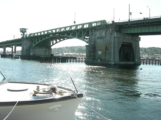
The 15th Avenue Bridge is its second name; built-in 1917, the bridge’s length is 2854 ft (870 m), carrying a streetcar.
Having the longest opening span of 218 ft (66 m), it became a National Catalogue of Historic Places member.
Ballard Bridge is a bascule (drawbridge) bridge that opens frequently and allows taller and giant boats to pass under it, due to which bridge remains down every weekday for a particular time.
It is made up of steel, featuring four lanes for moving traffic and insufficient space for sidewalks; that’s why it is a barrier.
Some visitors say there is no toll, while some claim you must pay $2.60 and $5.00.
Professional bicyclists have reported that some safety issues need improvements.
The process of opening or closing is worth seeing?
Address: 15th Ave NW, Seattle, WA 98107, United States
Also read about the best bridges in Illinois.
2. Fremont Bridge
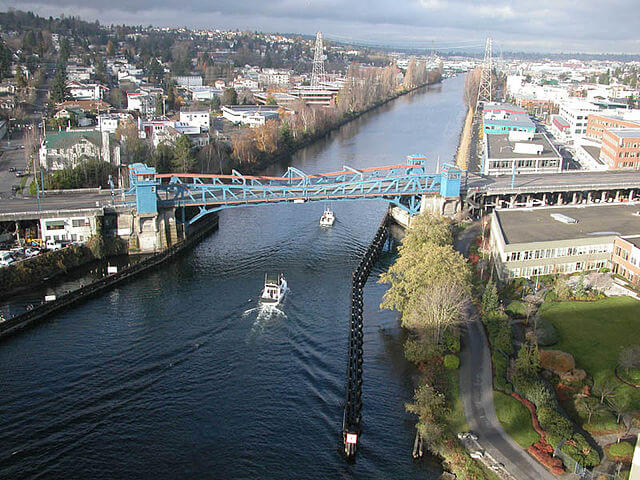
Also known as Fremont Avenue Bridge, occupying an overall length of 502 ft (153 m), with an opening span of 242 ft (74 m).
It was opened in 1917, a dual-leaf bascule link that connects North Fremont and Fourth Avenue north, connecting Fremont and Queen Anne.
When it comes to its appearance, its blue and orange colors give an aesthetically pleasing feeling while crossing it or watching its process of opening or closing.
Its heritage status can be predicted by its addition to the Historic Places Register of the United States.
This bridge is said to be among the busiest and most opening drawbridges, with an average opening of 35-40 times a day.
According to regular visitors, the Fremont Bridge remains closed to water traffic during rush and busy hours.
It features a bicycle counter that assists the bike traffic, increasing dramatically every year.
Have you visited this busiest drawbridge?
Address: Spans Lake Washington Ship Canal, Seattle, Washington
3. First Avenue South Bridge
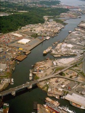
Between 1956-1998, this 3010 ft (920 m) bridge was designed as a paired double-leaf bascule bridge floating over the Duwamish River about 5 km south of downtown Seattle.
It was built to improve the industrial movements and to connect the northeast residents to the southwest communities.
The southbound span was opened for both directions traffic in 1997.
According to reports, it was the bridge with the state’s highest motor vehicle accident rate after its retrofit began.
Its southbound span of 2895 ft (2895) length was closed for repair due to drastically damaged by the Nisqually earthquake in 2001.
Presently, it is open to traffic in both directions, with an average daily traffic of 50 299 vehicles.
You can visit this bridge as the overall condition and superstructure are fair and satisfactory.
Address: Seattle, WA 98108, United States
Also read about the famous bridges in Illinois.
4. Aurora Bridge
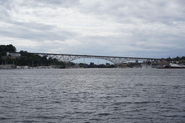
It’s officially called the George Washington Memorial Bridge, connecting Queen Anne to Fremont by carrying State Course 99 over the west edge of Lake Union.
Featuring 2945 ft in length, 70 ft in width, and 167 ft over the water, it is operated by the State Department of Transportation.
Opening for road traffic in 1932, it is considered one of the oldest bridges of the state and is also included in National Record Register.
Reports indicate that this place is famous for suicide jumpers, fatal incidents, murders, and accidents resulting in many deaths.
Due to its height and easy pedestrian access, it reported 230 suicides on the bridge, with the first suicide reported in January 1932.
It is now also referred to as a suicide bridge.
Do you think it’s real or a mere story?
Address: Aurora Ave N, Seattle, WA 98103, United States
5. Evergreen Point (Floating Bridge)
The 520 and the Albert D. Bridge are their other names, carrying Washington State Route 520 crossing Lake Washington.
Opened in 1963, it was designed as a four-lane floating bridge consisting of 33 pontoons made of precast concrete material.
The bridge’s total length is 7710 ft (2350 m), with a 116 ft width and a design life of 75 years.
It features four traffic lines separated by simple Jersey barriers, and at the center, it has a draw span that opens for large vessels.
The new bridge was later designed for a stable bridge in stronger storms and to raise the bridge deck higher than the old-designed bridge.
Its structure also includes a protected path for pedestrians and bicycles across the viaduct.
Address: Seattle, WA 98103, United States
Also, read about famous bridges in New York City.
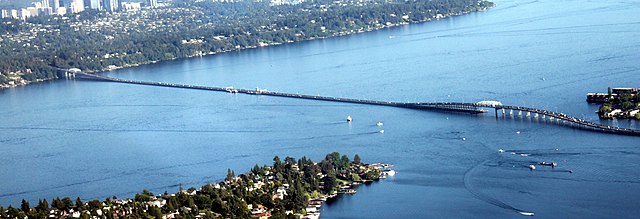
6. Homer M. Hadley Bridge
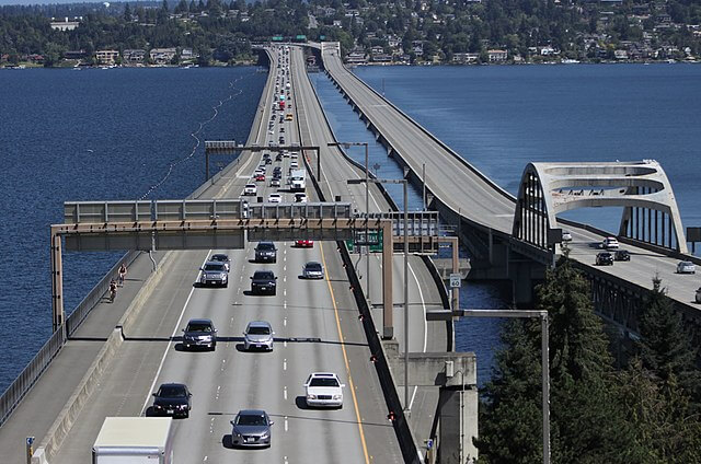
Also known as the Third Lake Bridge was opened in 1989, and it is acting as fluctuating connection in the municipal area of the state.
Its long span stretches over 5811 ft (1772 m), ranking it as the world’s fifth-longest bridge of its type.
Homer M. Hadley is among the Interstate 90 bridges that carry westbound tracks crossways Lake Washington between Seattle and Mercer Island.
This path also includes two barriers: an outer 54-inch (140 cm) and a 35-inch (89 m) of concrete to face the traffic.
It features an HOV lane, four westbound tracks for traffic, and an additional path of 9 ft on the north end for bicycles and pedestrians.
Overall, featuring multiple lanes for traffic and three shoulders, it is ranked as the 2nd widest floating bridge in the world.
Do you want to drive your vehicle on its wide lanes?
Address: Seattle, WA 98103, United States
7. University Bridge
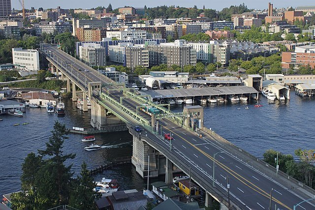
Inaugurated in 1919, a famous Washington State bridge in Seattle opened as Eastlake Bridge.
The Tenth Avenue Northeast is its other name, and it earned its present name in 1919.
Designed in dual-leaf bascule style, it carries the traffic of the Eastlake community across Portage Bay and connects University District to the north.
It was also recorded in the Historical Places Record Register, with the other two Ballard and Fremont bridges.
The bridge was locked in 2007 due to a 10-foot-deep (3.0 m) sinkhole that was created by a 24-inch water main broken.
Its electronics were refitted in 2014, and it also needs daily dousing with cool water to avoid widening during hot summer days.
Would you like to watch its electronic mechanism?
Address: Cheshiahud Lake Union Loop, Seattle, WA 98105, United States
8. Lacey V. Murrow Memorial Bridge
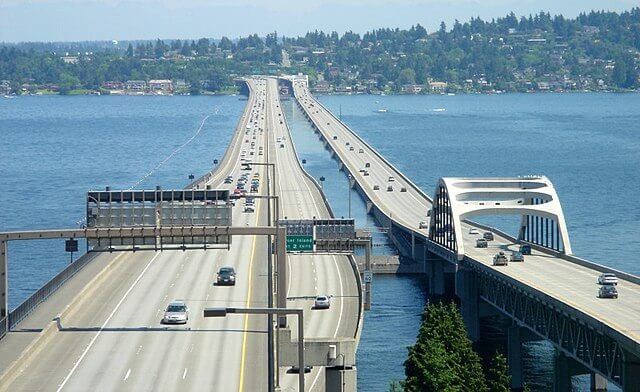
It was named the Lake Washington Bridge, but in 1967, it was renamed the Lacey Murrow, also known as Murrow Bridge.
In 1989, this 49-year-old bridge was shut down for three years for reformation, and a new bridge was opened.
Its 6620 ft (2020 m) length ranked it among the longest bridges in the world (The Albert D. Rossellini is the longest).
This bridge has an opening span of 202 ft for significant seawater circulation, allowing horizontal opening at the bridge’s center and facilitating traffic.
To facilitate Westbound traffic, Homer Hadley Bridge is used, which is adjacent to it.
This bridge also represents a Seattle official landmark and a tribute to Historic Civil Engineers.
Can you spend a whole day driving on this gorgeous bridge?
Address: 1330 Lakeside Ave S, Seattle, WA 98144, United States
Also, read about famous bridges in TX.
9. Montlake Bridge
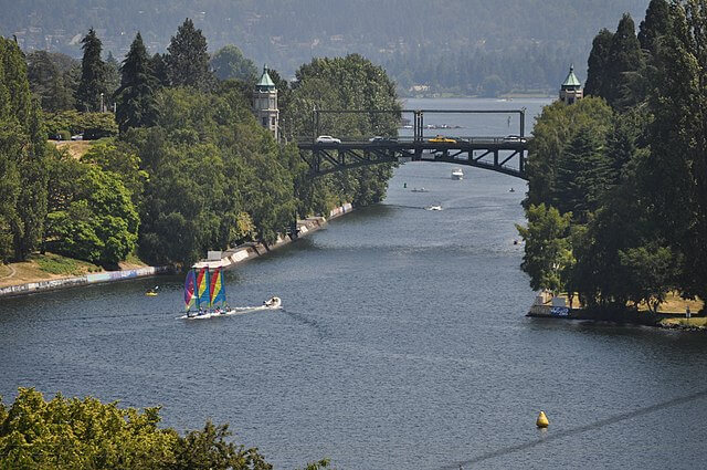
It’s a 344 ft (105 m) length double-leaf bascule bridge connecting the Montlake with the University District by carrying State Route 513 over Seattle Montlake Cut.
Historically, it was a unique architectural work designed by one of the famous architects of the University of Washington campus.
The clearance of 46 feet (14 m) is due to the bridge’s design and controlling towers, while some reports claimed it provides 48 ft (15 m) of vertical clearance.
It is listed among the four original bascule drawbridges with the highest clearance, and the other three are Ballard, Fremont, and the University bridges.
According to reports, this bridge averaged a volume of roughly 70,000 vehicular traffic and facilitated bicyclists and pedestrians on its sidewalks on both sides.
The average time of bridge opening is 4-5 minutes.
It is celebrated as the featuring spot of boating season’s “opening day” on the first Saturday in May.
You must visit this bridge in the first week of May to enjoy the boating season.
Address: Montlake Blvd E, Seattle, WA 98112, United States
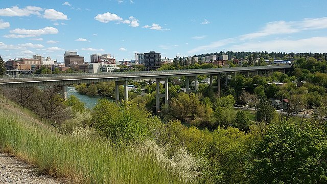
Bridges in Spokane, Washington
1. Monroe Street Bridge
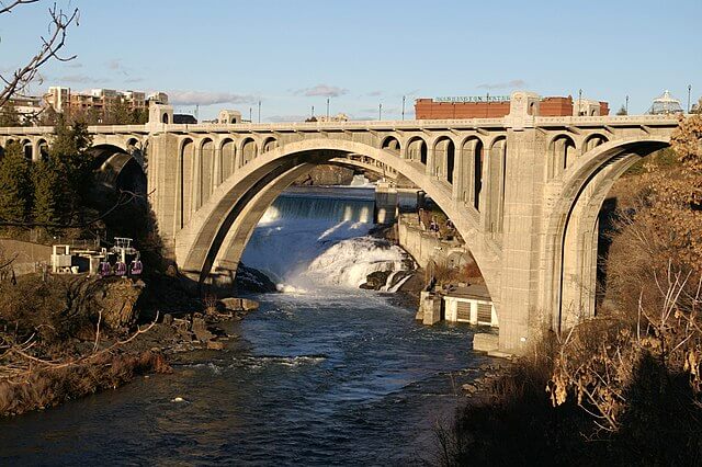
It’s a deck arch bridge spanning the Spokane River, built in 1911, and listed among the oldest bridges in the United States.
A total length of 136 ft (41.5 m) and 281 ft (85.6 m) made this Bridge the largest concrete bridge in the U.S. and ranked it the 3rd largest bridge globally.
According to different references, the design of this bridge for significantly copied from the Rocky River Bridge, Cleveland, Ohio, and it was constructed one ft longer to make it most prolonged and distinguish its replica from the original.
Its design features a variety of ornamental structures, including bison skills representing an inspiration of P.C. Shine, covered pavilions, and a chain-link railing motif.
This bridge is notorious as a suicide spot bridge because, according to Medical Examiner’s Office, there was reported an average of 2.4 deaths per year on the bridge.
Have you visited it before or know after reading it?
Address: 218 N Monroe St, Spokane, WA 99201, United States
2. Maple Street Bridge
It is a girder bridge that spans West Central to Downtown, waving over the Spoken River and the Peaceful Valley.
This is among the significant bridges along with Division Street Bridge and Monroe Street Bridge that cross the Spokane River.
It is also known as Maple Street Toll Bridge and has a total length of 1719 ft (524 m), standing 125 ft (38 m) above the water, and a 50 ft (15 m) expansive deck.
This bridge features two traffic lanes carrying traffic in both directions and a protected caged pedestrian walkway.
According to the reports in 2015, the bridge has an average of 40,600 vehicles daily.
After its opening, the toll tax was $0.10 (1958 – 1981) and $0.25 (1981 – 1990), which was removed in 1990.
An ironworker was killed during its construction.
Address: N Maple St, Spokane, WA 99205, United States
3. High Bridge (Latah Creek)
Other names include Latah Creek Viaduct and Latah Junction.
It is a railroad bridge that crossed Latah Creek in Spokane and was constructed in 1972.
This Bridge connects the former Northern Pacific mainline with the Spokane, Portland, and Seattle lines to its west.
It has a 3950 ft (1200 m) length, with its piers reaching up to 175 ft (53 m) from the canyon floor of Latah Creek.
High Bridge was constructed on a Box girder design made of high-strength steel 160 ft (49 m) in length.
The high-strength box girders bridge the canyon, having an adjacent span from 80 to 100 ft, and are maintained by the concrete piers.
Warren C. Heylman, named architect who designed it, considered this as its best work, and it has only a single rail track.
Address: Spokane, WA 99205, United States
4. Post Street Bridge
Initially, it was a wooden bridge built in 1885, but unfortunately, it didn’t last long and was replaced by an unusual metal truss, but the company claimed it was a hinged arch bridge.
Its structure type is a fixed concrete open-spandrel duck arch, while its approach spans are immovable and substantial (multi-beam).
When it was completed in 1917, it had pin-connected railroad truss bridges laying parallel on either side, but they do not exist today.
It features a chief span and two sides span, with its primary span length of 259 ft (78.9 m) and a structure length of 333 ft (101.5 m), along with a roadway width of 40 ft (12.19 m).
The present-day design of the bridge is the victim of significant alteration, but all the alteration was respective to the original design and appearance.
In 1937, an attempt was made to widen the bridge, and for this purpose, an additional third arc rib was added.
If you are a history student, you must research this bridge.
Address: W North River Dr, Spokane, WA 99201, United States
Bridges in Tacoma, Washington
1. Tacoma Narrows Bridge
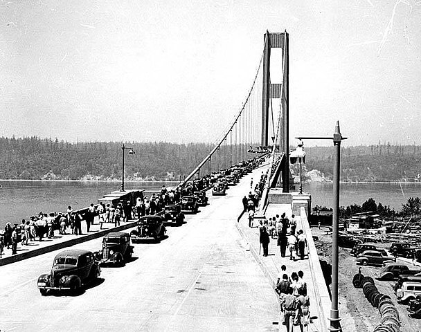
It was an interruption bridge built in 1940 and crossed over the Tacoma Narrows passage of Puget.
In 1938, it got the nickname the Galloping Gertie Bridge from its construction workers.
It was made functional for the traffic in the opening year, and unfortunately, the bridge collapsed, which is described as Spectacular, and got the attention of physicists and engineers.
Famous among the longest bridges in the world, it features 5939 ft in length, and its longest span stretches over 2800 ft behind the Golden Gate.
It collapsed with winds of speed 64 kilometers per hour as the deck started oscillating in an alternative twisting pattern.
The bridge’s remaining portion, such as the pillars and shackles, was used as the waste metal.
Collapsing of this bridge is a mystery and has a lasting effect on everyone.
Address: Between Tacoma and the Kitsap Peninsula, WA 99205, United States
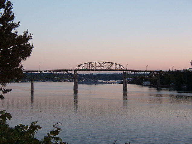
2. East 21st Street Bridge
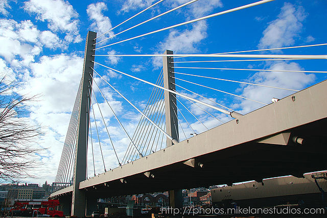
Also known as Foss Waterway Bridge and was opened entirely in January 1997.
Supported by long wires, it features two towers having a length of 180 gt with four tracks of State Route 509 crossing the Thea Foss Waterway.
Different reports are present on the length of the bridge, which include 682 ft, or 707-ft, or 992 ft.
Among these lengths, the most accurate is 682 ft with 72 ft (21.9 m) width.
This bridge was designed to replace the Murry Morgan 11th Street bridge.
According to traffic analysis, the average daily traffic on the bridge is 37,602.
Its long cables connected with the central pillars give a beautiful and fantastic view to its visitors and other watching far from it, especially during the night.
If you plan to visit it, see it in the evening.
Address: WA-509, Tacoma, WA 98421, United States
3. Bridge of Glass
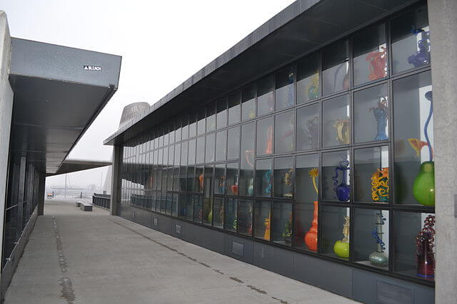
It is a gifted pedestrian bridge to Spokane City and was officially opened in 2002.
The Bridge of Glass is a partially covered footbridge over Interstate 750 and is famous for its unique artwork.
It connects attractions along Pacific Avenue and other historical art museums of Tacoma and the state, making Museum Row in Tacoma.
The bridge also connects the Museum of Glass on the Thea Foss Waterway and downtown.
According to its artwork designer Dale Chihuly, this bridge is actually “the gateway that welcomes people to Tacoma.
While crossing the bridge, you will observe three Chihuly glass installations featuring Sea form Pavilion, a covered portion of 15 m suspending 2364 pieces.
These colorful marine-life pieces, along with centrally located Crystal Towers of 40 ft, give an eloquent sight to its visitors and pedestrians.
If you are living in Tacoma, make sure you visit this beautiful and unique artwork.
Address: Bridge of Glass, Tacoma, WA 98402, United States
Bridges in Vancouver, Washington
1. Interstate Bridge
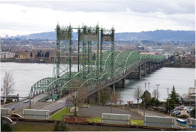
Other names are Oregon-Washington Bridge, Columbia River Interstate Bridge, I-5 Bridge, Portland-Vancouver Interstate Bridge, and Vancouver-Portland Bridge.
It was listed as the “Portland-Vancouver Highway Bridge” in the National Historic Places Register.
Featuring a couple of clone vertical-lift, it moves Interstate 5 vehicles over the River and links both cities’ communities.
The total length is 3538 ft with a height of approximately 230 ft and the longest span of 531 ft.
Opened in 1917, It carries both sides of traffic, while another identical bond was inaugurated in 1958, converting every side to bring one-way traffic.
According to traffic reports, this bridge handles above 140,000 vehicles daily.
Its green structures over 3500 ft long assist traffic of south and north, featuring three lanes for each side.
Visitors claimed that this bridge is the reason for the congestion of both waterborne and road vehicles.
Address: I-5 Bridge, I-5, Vancouver, WA 98660, United States
2. Burlington Northern Railroad Bridge 9.6
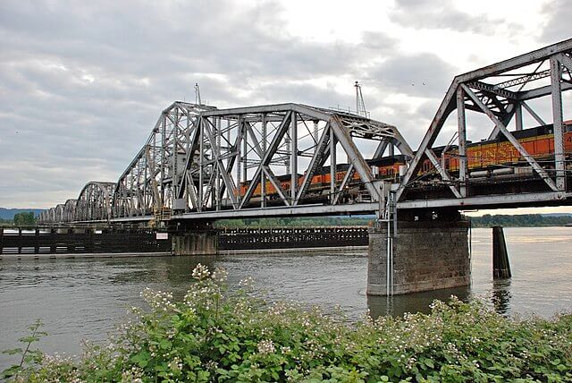
Famous as BNSF or the Columbia River and was designed on a truss-like connection that crosses the Columbia River.
It is a 2807 ft (856 m) long bridge that opened in 1908 and was the first bridge crossing the Columbia River.
The design of the bridge is swing-based, Pratt truss based, featuring a main span on its base to assist the movement of more long and longer vessels underneath.
Two tracks are present under the supervision of Union Pacific, BNSF, and Amtrak.
This bridge is the only one remaining among the two in the Portland metropolitan area.
Figure nine, point six, in its name, indicates its measurements in miles, and the exact figure is used for bridges 5.1 and 8.8 on the same line.
The opening of the swing span for a barrage gives a beautiful view while watching far from it or aerially.
If you are a photographer or Videographer, you must catch its opening.
Address: Columbia River, Vancouver, WA 98660, United States
3. Glenn L. Jackson Memorial Bridge
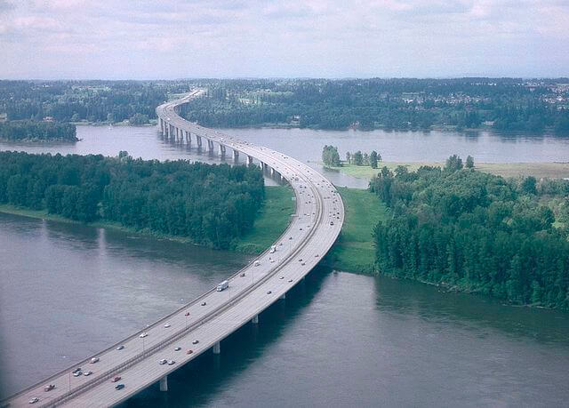
Also known as the I-205 Bridge carrying Interstate 205, which is acting as a bypass of the Oregon region.
It consists of segments that span the River and connects three areas, which is why it is mapped in Vancouver City.
Initially constructed as a portion of the Portland Interstate, but after sometimes the name was changed to Veteran’s Memorial Freeway.
The one segment was manufactured to avoid disrupting waterborne traffic, and now it has pieces weighing upwards of 200 tons.
According to the reports, three to four people died during its construction.
It has a record of 125,000 pedestrians crossing the bridge in a single day, and it was a festival named People’s Day.
This bridge features an identical structure with multiple lanes and a bicycle and walking track of 9 ft wide in between the roads.
Have you booked your ticket for Vancouver, Washington?
Address: Portland, Vancouver, WA 98660, United States
Bridges in Skagit, Washington
1. Deception Pass Bridge
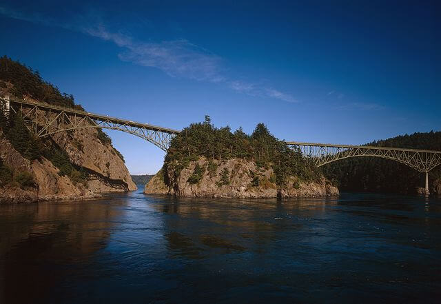
It is a mutual title for more than one bridge: dual-lane bridges on State Path 90 that connect Whidbey and Fidakgo Islands.
Shortly, it connects two islands, Whidbey of Island County and Fidakgo of Skagit County, respectively.
Designed on a Deck arch, cantilever based, this bridge has two spans locating Canoe Pass and Deception Pass on its north and south, respectively.
While Pass Island lies centrally in these bridges.
This bridge is most famous for providing majestic photography scenery of the area.
Its addition to the National Historical Record Catalogue made it more significant in 1982.
In 2021, a repainting project was completed with Evergreen paint free from lead and replaced rusted steel pieces.
If you are looking for a photo for a photography competition, you must take a shot at this place.
Address: North Whidbey, Oak Harbor, WA 98277, United States
2. I-5 Skagit River Bridge
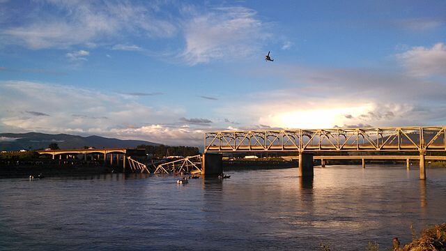
Categorizing as a Through-truss bridge, this bridge was manufactured in 1955, connecting the cities of Mount Vernon and Burlington and providing an essential link between Vancouver and Seattle.
This bridge is made up of steel consisting of an overall length of 1112 ft (339 m) and a width of 72 ft (22m).
Its featuring spots are four consecutive spans that are structurally independent and give a beautiful look to the bridge.
This bridge is famous for its 2013 collapse when its northernmost span collapsed due to the striking of an oversize load truck with overhead support beams.
Its span carrying Interstate 5 across the Skagit River collapsed, resulting in the falling of three people in the river who were rescued later.
Two temporary bridges were constructed and placed on the damaged span while the permanent bridge was built again.
You can research this disaster incident and find a lot of surprising information.
Address: Mount Vernon, WA 98277, United States
Bridges in Kitsap, Washington
1. Hood Canal Bridge
This is officially called William A. Bugge Bridge, carrying State Route 104 along Hood Canal of Puget Sound and connecting the Olympic and Kitsap Peninsulas.
Inaugurated in 1961, it was the 2nd concrete moveable bridge that links local people, commuters, and recreational visitors.
It is a floating bridge constructed on a Pontoon bridge with a retractable draw span designed, and it took a decade for its design and criticism.
With a total length of 7869 ft, the longest span of 600 ft (183 m), and a floating portion of 6521 ft, it is ranked third as the longest bridge in the world and first among the saltwater tidal bridges.
Its convenience significantly impacts economic development in Jefferson County, Washington.
Have you visited any floating bridges before?
Address: Kitsap and Jefferson counties, Washington, U.S.
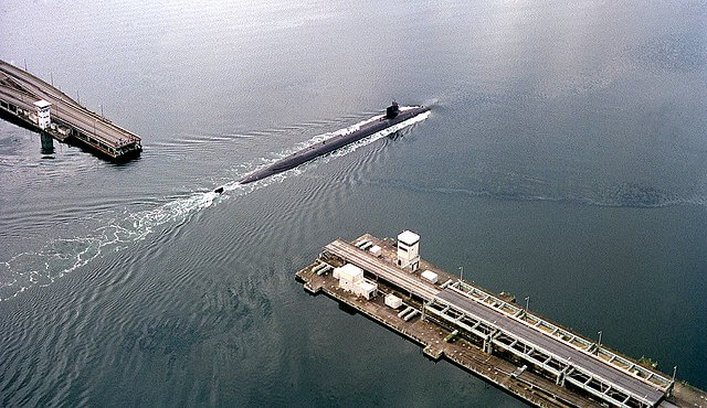
2. Manette Bridge
This bridge was opened in 1930 and built as the Bremerton-Manette Bridge to assist families in commuting from Bermerton’s east to the west.
The Manette Bridge was designed as a steel truss bridge spanning the Port Washington Narrows and connecting the communities of Manette to downtown Bremerton.
Inaugurated as a toll bridge that charged $.25 per car and $.05 per pedestrian, but now it’s toll-free since 1972.
This connection is why this bridge falls in Bremerton, Kitsap County’s city.
The bridge is 82 ft (25 m) above the water with a clearance between the piers of 321 ft (98 m) and has a total length of 1573 ft (479 m).
It has six spans and four piers in the water, which gives this bridge a gorgeous look.
Are you going to spend some time in this beautiful spot?
Address: Manette Bridge, Bremerton, WA 98337, United States